
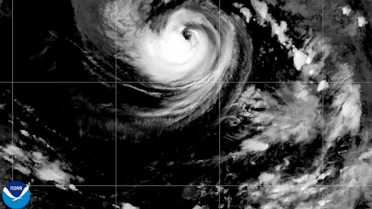
Duufaan Kulaylaha ah oo la odhan jiray Karina ayaa Axadii ku xoogowday oo noqotay hurricane ku dhex jirta Badweynta Baasifigga. Xarunta Qaranka ee Hurricane-ga ayaa sheegtay inaysan dhulka wax khatar ah u hayn, laakiin ay mowjado khatar ah keeni karto.
Xaaladda Duufaanta Karina
Karina waxay heshay dabayl joogto ah oo gaaraya 80 mayl saacaddii (130 kiilomitir saacaddii), taas oo ka dhigaysa Category 1 hurricane, sida uu qabo Xarunta Qaranka ee Hurricane-ga. Duufaantani waa mid aan dhulka u khatar ahayn, iyadoo xariggeedu uu ku sugan yahay badda fog.
Duufaanta Karina waxay ku taallaa qiyaastii 820 mayl (1,325 kiilomitir) koonfur-galbeed ee cidhifka koonfureed ee Baja California Peninsula ee Mexico. Waxay u socotaa woqooyi-galbeed xawaare gaaraya 15 mayl saacaddii (24 kiilomitir saacaddii).
Saadaasha iyo Saamaynta
Saadaaliyayaashu waxay sheegeen in Karina ay noqon karto duufaan weyn usbuucan, iyadoo duufaan weyn ay tahay Category 3 ama ka sare. Inkastoo ay ka fogaanayso dhulka, mowjado ka yimaada duufaanta ayaa keeni kara dhinacyo khatar ah oo ay ka mid yihiin dabbaal khatar ah oo xeebaha southwest Mexico iyo Baja California Peninsula.
Meel kale oo ka mid ah Baasifigga, Tropical Storm Lowell waxay ku jirtaa 1,150 mayl (1,850 kiilomitir) koonfur-bari ee Hawaii, mana hayso khatar dhulka. Tani waxay muujinaysaa in labada duufaan aysan midna dhulka u wadin khatar.
Xilliga Duufaannada Atlantigga
Hay'adda National Oceanic and Atmospheric Administration ayaa saadaalisay xilli duufaan oo celcelis ka hooseeya Badweynta Atlantigga sababtoo ah El Nino. Tani waa qiimeyn ay sameeyeen khubarada cimilada ee qaranka.
Hay'addu waxay saadaalisay siddeed ilaa 14 duufaan oo magac leh, iyadoo saddex ilaa lix ka mid ah ay gaarayaan xoogga hurricane, mid ilaa saddexna ay noqon karaan kuwo gaaraya heerka duufaan weyn.
Tropical Storm Karina intensified into a hurricane on Sunday, reaching Category 1 status with sustained winds of 80 mph (130 km/h). The system remains well offshore and poses no direct threat to land, though forecasters warn it could strengthen further this week.
Karina's Current Position and Movement
The newly formed hurricane is situated approximately 820 miles (1,325 km) southwest of the southern tip of Mexico's Baja California Peninsula. It is tracking northwest at 15 mph (24 km/h) along a forecast path that carries it further into the open Pacific Ocean.
The National Hurricane Center confirmed that Karina's maximum sustained winds reached 80 mph (130 km/h), officially classifying it as a Category 1 hurricane. A major hurricane is defined as Category 3 or greater on the Saffir-Simpson scale.
Potential for Further Intensification
Forecasters indicated that Karina could evolve into a major storm within the coming days, although the system is expected to remain far from populated areas. While the hurricane itself will not directly impact land, its swells are likely to generate dangerous surf and rip current conditions along parts of southwest Mexico and the Baja California Peninsula.
The National Oceanic and Atmospheric Administration has projected a below-average Atlantic hurricane season due to the influence of El Nino. The agency predicted eight to 14 named storms, with three to six reaching hurricane strength and one to three intensifying to major hurricanes.
Other Pacific Systems Under Watch
Elsewhere in the Pacific basin, Tropical Storm Lowell was located about 1,150 miles (1,850 km) southeast of Hawaii. Like Karina, Lowell posed no threat to land and remained a non-threatening system in the open ocean.
The National Hurricane Center continues to monitor both systems closely. While neither storm is expected to make landfall, the combination of Karina's strengthening winds and Lowell's presence in the basin requires ongoing observation by meteorological agencies.
Ilaha iyo xuquuqda sawirka
Sawir: ABC News Xigasho